


.gif)


|
Signature Sponsor


September 9, 2020 - Black Diamond is a peculiar name for a town. Newcomers and perhaps a few old timers seldom consider that black diamonds once referred to those dark and shiny chunks of coal which led to the town’s formation. There are just a few Black Diamonds in the world including one each in Alabama, Florida, Alberta Canada, and a collection of coal mining communities in the Appalachia region of southeast Ohio who’ve banded together as the Little Cities of Black Diamonds. Ours was named for the Black Diamond Coal Mining Company of Nortonville, California, whose investments in the Washington Territory led to the town’s founding in 1882. With the arrival of the Columbia & Puget Sound Railroad (C&PS) in 1884, Black Diamond grew rapidly and soon became the biggest coal producer in King County. Over the decades it was second only to Roslyn in Washington state. Mines opened in steady succession as follows:
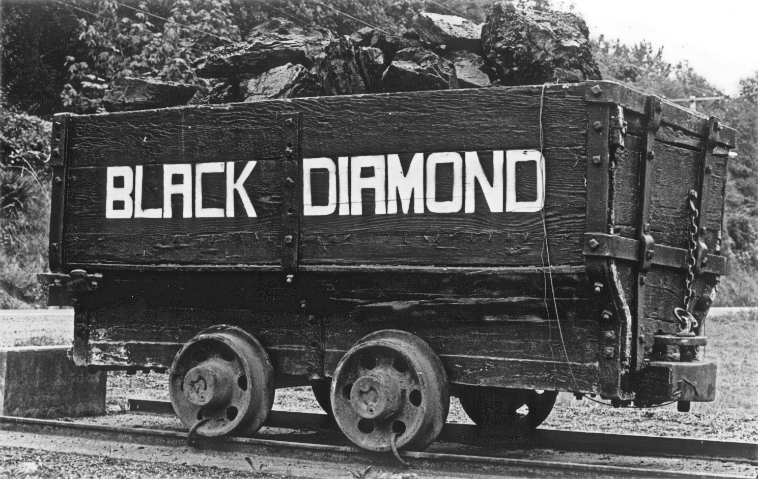
The coal car at Miners Memorial park in October 1982. Photo from PCC archives.
Underground and surface operations continued on nearby coalseams through the 1950s and 1960s, but as explained below those underground and surface mines were considered to be more closely associated with Franklin so are not a part of this Black Diamond list. Note regarding mining districts: The above list attempts to capture coal mines primarily associated with Black Diamond. Yet, it’s sometimes difficult to decide where a mine should be classified. The same McKay coal seam begins in Ravensdale, runs south through Black Diamond, then east to Franklin, and ends in Cumberland. The division between Black Diamond and Franklin is even more ambiguous, as mines operated on several slopes of what’s commonly called Franklin Hill (called Lawson Hill on its west slope). For preparation of this list, mines that drain towards the Green River were considered Franklin, while the various #7 mines located south of Lake 12 were classified as Black Diamond.
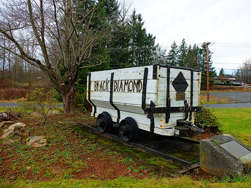
Photo of coal car at Miners Memorial park in 2020. Photo by Robert Dobson. With the 1946 closure of the Franklin #7, underground mining in Black Diamond essentially ended, though it continued in nearby Ravensdale, Franklin, and Kummer. Still a few one-man operations in town by local entrepreneurs like Dave Evans, Billy Casper, Tom Maks, and Louie Draghi persevered. Some of these tiny operations, which produced only a few hundred tons per year, continued into the late 1960s. Also, the wash plant (aka preparation plant) located at the site of the historic Mine #11 continued operating through 1990. Surface mining returned to the east edge of city limits in 1982 when Palmer Coking Coal opened their McKay-Section 12 mine. That mining was completed in 1986 and the fully reclaimed site won a reclamation award from the state. It was located east of Botts Drive and south of the Green River Gorge Road. A new Pacific Coast Coal Co., completely different from historic company except in name, opened the John Henry No. 1 surface mine in 1986 with coal processing at the Mine #11 wash plant. Significant levels of mining continued until 1997 when a landslide in this open pit mine crippled operations. The John Henry site is currently engaged in reclamation activities. This mine occupies property located south of the Green River Gorge Road and west of Lake 12. Following Black Diamond’s incorporation in 1959, community leaders hoped to instill civic pride by highlighting the town’s coal mining roots. In early 1962, a group of volunteers supported by the Lions Club, created the wooden coal car monument located at the intersection of Highway 169 and Roberts Drive on land owned by Palmer Coking Coal Company (Palmer). Most of the volunteers were once coal miners. The featured cart was donated by the Ed Johnson Coal Company and painted white with black lettering. That original effort was headed by Jules Dal Santo. Others who helped included Archie Eltz, Gomer Evans, Darrel McCloud, Louis Zumek, and Frank Zumek.
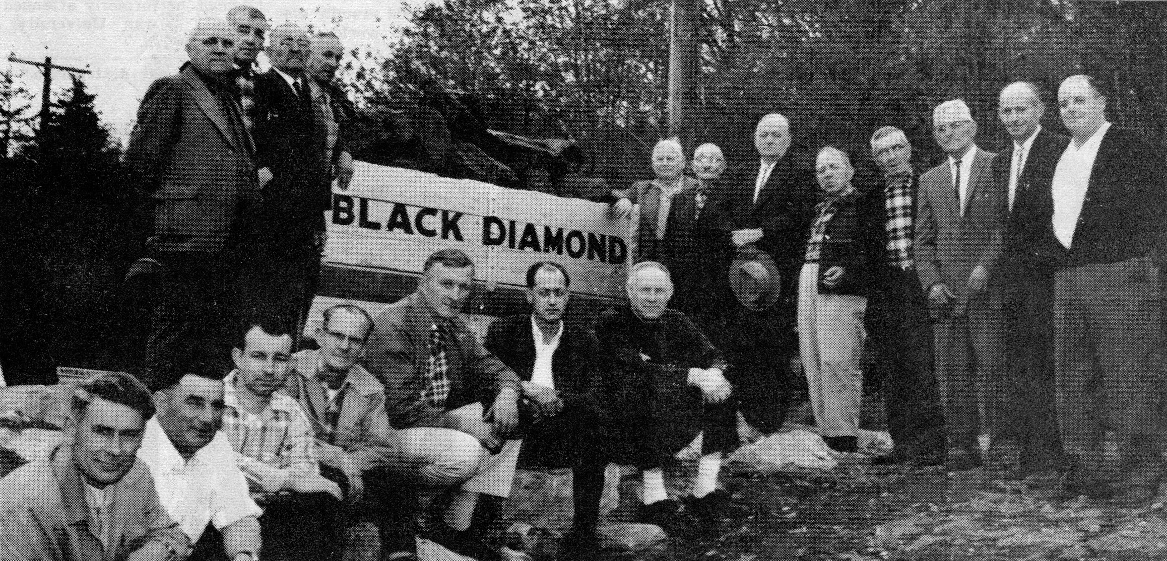
The coal car and assembled volunteers at its dedication in May 1962. Photo from the Enumclaw Courier-Herald. On May 30, 1962, the coal car located on the triangle-shaped property was dedicated. Shown kneeling from left are: Keith Timm Sr., James Vernarelli, Howard Botts, Ernest Richardson, George Savicke, Roy Darby, and Ted Barner. Standing from left are: Walter Mislenski, John Birchall, Mike Sogura, Domenico Geminiani, Fred L. Roberts, Tom Wieltschnig, Joe Bertelli, Joe Dal Santo Sr. , Tony Signani, R.W. Boyovich, Frank Costi, and Henry Hawthorne. This photo appeared on the front page of the Enumclaw Courier-Herald. In 1975, Palmer donated the parcel where the coal car had been placed to the City of Black Diamond. The site was surveyed by Louie Zumek and intended for a park and picnic area. On Zumek’s survey map it’s called the Miner’s Memorial site. On one occasion that coal car was completely destroyed by a wayward automobile, yet restored by Gerald Gauthier Sr. The wooden coal car appearing in the nearby April 1977 photo may be Gauthier’s restoration. At another point, the coal car colors were reversed as seen in the October 1982 photo of that same wooden mine car filled with lumps of coal. That photo was taken just after the 100th anniversary marking Black Diamond’s centennial.
One of four coal cars marking the entrances to Black Diamond. Photo by Robert Dobson.
However in May 1990, a trailer pulled by an asphalt truck smashed into the coal car. Historical society members including Ted Barner, Donald Botts, Bob Burdick, Bob Eaton, Martin Moore, Al Shay, and Carl Steiert rebuilt the splintered wreck from scratch using treated lumber so it would last longer. A wheeler loader from Palmer moved the car from the museum and positioned it back in place. Traditionally, large chunks called lump coal were placed in the cart. But so many were stolen by treasure-seekers and those heating with coal, they were later replaced by smaller pieces called stoker coal. In 2002, Dan Dal Santo, the city’s utilities supervisor and nephew to Jules Dal Santo, spearheaded efforts to install four more coal cars one at each of the four main road entrances into the city:
The iconic coal car at the Miner’s Memorial site on SR 169 may once again need to be moved as traffic improvement plans call for a new roundabout to replace the awkward triangular intersection. Whether the treasured coal car is placed in the middle of the future roundabout (though State rules may disfavor such distractions) or on adjacent property set aside for stormwater treatment and historical interpretation is still to be decided. What’s not in dispute are the historical roots of the town carved out of the wilderness which grew into a city that’s still prides itself as “Black Diamond.” |


|