West Virginia Geological and Economic Survey: Quietly Driving Economic Development and Innovation

By Charles Young
February 8, 2021 - There are nine agencies within the West Virginia Commerce Department, ranging from the Division of Natural Resources to the Division of Rehabilitation Services.
Of these agencies, the West Virginia Geological and Economic Survey is arguably among the most important but the least well-known to the general public.
“Some might say, ‘Why is the Survey a Commerce agency?’” said Commerce Secretary Ed Gaunch. “The truth is they do an incredible amount of work for the other agencies that are here in Commerce — in terms of determining what the coal reserves are; what the natural gas, oil and the wet liquids that come from natural gas what those reserves are; how best to get to them; and how best to take advantage of those resources.”
.jpg)
Information maintained by the West Virginia Geological and Economic Survey contains information about coal, oil and gas in the state going back for decades.
Photo: WVGES
.jpg)
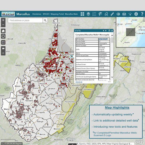
The West Virginia Geologic & Economic Survey maintains a database of information related to oil and gas activity in West Virginia.
Image: WVGES
The West Virginia Geologic & Economic Survey is an important source of information relating to West Virginia's mineral resources.
Image: WVGES
Jessica Moore, state geologist and director of the Geological and Economic Survey, said she always describes the work of her team the same way.
“I like to say that we are the geologic consultants for the people of West Virginia,” she said. “Our role is to collect and disseminate basic data and applied science in order to be responsive to requests from a variety of levels.”
Requests can include inquires from the office of Gov. Jim Justice or from landowners interested in oil and gas interests, Moore said.
The agency, which consists of 35 full-time employees, is divided into three main departments: Coal, oil and gas and general geoscience, Moore said.
“In oil and gas, this could be in relation to the shale gas boom that we’ve experienced over the past decade or decade and a half,” she said. “A lot of the work we do in oil and gas is more of these large, multi-state projects to really look at the Appalachian basin holistically and be able to understand the gas accumulation.”
In recent years, her team has contributed to the Utica Shale Playbook and a study on the potential of the proposed Appalachian Storage Hub, Moore said.
The day-to-day duties of the oil and gas department involves mapping and tracking drilling activity in the state, Moore said.
“We receive that information from the DEP so that we can characterize these natural gas reservoirs so we know their potential moving forward,” she said.
The coal department collects information on mining in order to digitally compile spatial representations of mining and has collected trace element data on coal samples for decades, Moore said.
“We’ve been delving back into that data these days to look for critical mineral concentrations and rare earth elements, which are necessary for all sorts of modern technological applications. I like to say that if any technology has gotten smarter, smaller, faster or greener, it has used one of these critical minerals,” Moore said.
The general geoscience department handles “boots on the ground mapping,” Moore said.
“Bedrock geologic maps are essential to any kind of infrastructure development,” she said. “For instance, we’ve been working with the [Division] of Highways to map along the Corridor H route.”
The COVID-19 pandemic has forced the agency to work remotely and move to online collaboration, Moore said.
“We were able to transition pretty well. Having computing skills and being able to map digitally, those were things that we could do at home,” she said. “Probably the biggest impact was with our field mapping. We lost almost an entire mapping season because we could not send people out into the field. Now we’re just trying to catch up a little bit in that aspect.”
The work of the WVGES has shifted over the years to fit the evolving needs of the various state agencies it serves, Moore said.
“What we’ve seen in the past is that our data and our legacy of data collection can really be leveraged in a lot of different ways, even ways that we don’t know yet,” she said. “An example is shale gas. In the ‘70s and ‘80s the Geological Survey was a participant in the information Eastern Gas Shale Product.”
The information collected in the study was fundamental to the development of modern drilling in the Appalachian regions, Moore said.
“Our role really is to collect and to archive and to have that deep contact knowledge, to know what we have and how we can leverage that to new energy initiatives and new economic development initiatives,” she said.


.gif)